

About Palestine
About Palestine
PALESTINIAN CULTURE
على هذه الأرض ما يستحق الحياة
We have on this land that which makes life worth living.
These words by the renowned Palestinian poet Mahmoud Darwish capture the essence of a culture that is rich, resilient, and deeply rooted in its land and people. Palestinian culture thrives through its strong connection to heritage, shaped by centuries of agricultural tradition and layered historical influences.
At the heart of Palestinian life are values such as sincere hospitality, a profound sense of family, and a deep attachment to the land. One of the most iconic symbols of this bond is olive oil, regarded as a national treasure. Olive trees, some thousands of years old, blanket the hills and valleys of the region not only as a vital economic resource, but as a spiritual and cultural emblem. Palestinian extra virgin olive oil forms the basis of daily meals, often paired with Za’atar - a blend of thyme, sesame seeds, and sumac - and used in beloved traditional dishes such as Musakhan, Maqluba. In addition to these savory specialties, Palestinian cuisine also includes renowned desserts like Kunafeh, a sweet pastry made with cheese or cream and shredded phyllo dough soaked in sugar syrup - a symbol of hospitality and celebration - and Qatayef , stuffed pancakes traditionally served during Ramadan, filled with nuts, cream, or sweet cheese and drenched in syrup.
Traditional handicrafts also hold a central place in Palestinian cultural life. Tatreez , or hand embroidery, is recognized by UNESCO as intangible cultural heritage. Its intricate patterns and vibrant colors vary from village to village, often adorning the Thob, the traditional women's dress still proudly worn today. Another powerful expression of Palestinian identity is the Dabkeh, a folkloric dance performed collectively at weddings, festivals, and national celebrations. Its synchronized steps and rhythmic stomping are both a celebration of joy and an expression of resistance, strengthening communal ties and shared identity.
Altogether, Palestinian cuisine, dress, dance, music, and literature form a vibrant and enduring cultural heritage - one that continues to thrive both within Palestine and across its global diaspora. It is a heritage that embodies continuity, identity, and resilience - a testament to the enduring truth that on this land, indeed, there is that which makes life worth living.


Palestinians pick olives during a ceremony marking the start of the olive harvesting season last year in Deir el-Balah in the central Gaza Strip

Woman holding a plate of Musakhan—Palestine’s iconic dish, rich with sumac, onions, and love.

A master at work - preparing Kunafeh at the legendary Al-Aqsa Bakery in the Old City of Nablus.
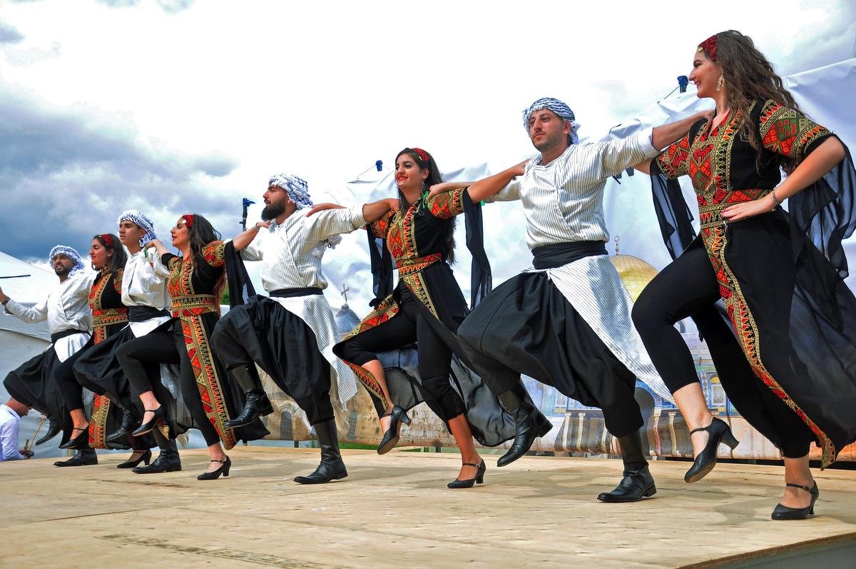
Palestinians performing Dabkeh — a powerful symbol of resistance, joy, and heritage.

Al-Masjid al-Aqsa
Al-Masjid al-Aqsa, once the first Qiblah for Muslims and the site of the Prophet Muhammad’s Night Journey (Isra and Mi'raj), holds great religious significance as Islam’s third holiest mosque. Located in the southeastern part of the Old City, this expansive site includes walls, courtyards, and multiple buildings such as the Al-Qibli Mosque - commonly referred to as Al-Aqsa Mosque- (a), the Dome of the Rock (b), the Dome of the Chain (c), and the prayer hall known as Al-Marwani.
Souq Al-Qattanin Souq Al-Qattanin
Souq Al-Qattanin is located along the central part of the western corridor of the Holy Mosque. It provides access to the Haram courtyards through Bab Al-Qattanin on the western side and stretches westward to connect with Al-Wad Road. The market extends approximately ninety-five meters and historically served as a hub for cotton trading, featuring numerous shops that offer a wide range of textiles.
The market was reconstructed in 1336 AD by Prince Saif al-Din Tankaz, who governed the Levant under the rule of Sultan al-Nasir Muhammad. It consists of fifty shops arranged opposite each other along a street that is ten meters wide, with each shop designed to be uniform in size and shape. The ceiling includes openings that allow natural light and ventilation into both the street and the shops. In 1974, the Jerusalem Endowments Department undertook a restoration project that revitalized the market.
Architecturally, Souq Al-Qattanin is notable for its covered arcade and an upper floor that contains rooms meant for travelers to stay overnight above the shops. The market also includes two public bathhouses — Hammam Al-Shifa and Hammam Al-Ain — along with Khan Tankaz Al-Nasiri and Khan Al-Qattanin, adding to its historical and cultural significance.

The Church of St. George – Al-Taybeh
Located east of Ramallah, in the town of Al-Taybeh, the Church of St. George stands as one of the region’s most important historical churches. Perched atop a high hill overlooking the town, this church dates back to the Byzantine period, reflecting its long-standing spiritual and cultural significance. The church complex is expansive, covering approximately 26 to 28 square meters, and features three interconnected halls. Remarkably, despite centuries of exposure, significant portions—especially the eastern sections of the middle and southern halls—remain well preserved.
Beyond its Byzantine foundations, the site also includes a major building from the medieval era, highlighting the church’s enduring prominence across different historical periods. The church is closely linked to Al-Kharder, or Saint George, a figure deeply revered in both Christian and Muslim traditions across Palestine. The site’s rediscovery was followed by a joint archaeological effort led by Palestinian and French teams, who undertook thorough cleaning and restoration of the church complex.
In 2009, a notable archaeological discovery was made in the church’s western courtyard. Excavations uncovered a tomb containing hundreds of artifacts dating from both the Byzantine and medieval eras, providing compelling evidence of the site’s continuous use and historical importance over the centuries.
Today, the Church of St. George in Al-Taybeh serves as a vivid reminder of the region’s rich religious and cultural heritage. Its well-preserved structures and archaeological finds offer invaluable insights for historians, scholars, and visitors, while its association with the revered Saint George reinforces its status as a place of profound spiritual and historical significance in Palestine.

The Ottoman Court building
Situated in the heart of Ramallah’s old city, the Ottoman Court building is among the oldest historical landmarks in the city, distinguished by its unique architectural style. Constructed during the late Ottoman period, it holds an important place in the region’s history. In 1902 AD, Ahmad Murad, a notable figure from Jerusalem, was appointed by the Ottoman government as the district director when Ramallah was recognized as the administrative center of the area. As part of the city’s development, the government established key institutions, including this building which served as both a police station and a court—considered essential symbols of Ottoman authority.
The building consists of two floors: the ground floor features three spacious rooms designed in traditional Arabian style, each approximately 25 square meters in size with separate doors. The upper floor contains three smaller rectangular rooms adorned with Arabic arches, as well as an outdoor theater with a seating capacity of about 100 people. Surrounding the building is a large playground for children.
Throughout its history, the building has served multiple purposes. In 1883, Quaker missionaries operated a medical clinic there. During the 1948 war, it became a refuge for displaced families. Mid-20th century uses included functioning as an olive press, a banana fermentation site, storage spaces, and even animal barns.
In 2003, the Ramallah Municipality took steps to preserve the structure, partnering with Riwaq, a renowned center for architectural conservation, to restore and protect the building. Today, the Ottoman Court building houses a children’s library with an extensive collection of approximately 8,000 books and CDs. The library also includes two dedicated research units for young readers. Collaborations with leading publishers and prominent libraries in Palestine and the Arab world ensure access to the latest children’s literature at both local and regional levels.
The building’s role extends beyond a lending library; it serves as a vibrant community space offering a wide range of workshops and activities. These include arts and crafts such as ceramics and porcelain work, early learning support programs, music classes, cooking workshops, puppet theater, and parent-child interactive sessions. It also hosts major youth initiatives and events, including the Ramallah Children's Municipal Council, the Children's Marathon, the Children's Festival, Nowar Nissan, and the "Let's Go to the Garden" program.

Deir al-Qilt Monastery, Monastery of Saint George of Choziba
Perched on the slopes of Wadi al-Qilt, along the ancient route between Jerusalem and Jericho, the Monastery of Saint George—known as Deir al-Qilt—is carved directly into the rock face, giving the impression that it hangs dramatically atop the cliff. Surrounding the monastery are numerous caves that once sheltered hermits and monks.
Originally a small church, the site was transformed into a monastery in 480 AD. It reached its peak in the late sixth century under the leadership of Saint George of Choziba, when around 2,000 monks lived there. The monastery also holds the tomb of Saint George. During the Persian invasion, the complex suffered significant destruction, with many monks killed or scattered.
-
Despite repeated damage over the centuries, a small monastic community persisted until the twelfth century, when Emperor Manuel I Komnenos commissioned extensive repairs. Later, between 1878 and 1901, the Greek monk Kallinikos restored and expanded the monastery, giving it much of its current form.Today, the Palestinian Ministry of Tourism and Antiquities is working to have Wadi al-Qilt recognized as a UNESCO World Heritage Site, highlighting its unique historical and natural importance alongside other notable archaeological and natural landmarks in the region.
Every year on January 20th, the Orthodox Church celebrates the feast of Saint George’s Monastery. Pilgrims travel to the site by narrow mountain paths—on foot or by animal—to participate in festivities that begin at dusk and often continue until dawn.

Dead sea
The Dead Sea, also known as the Sea of Salt or Sea of Lot, is a remarkable natural body of water located in the Jordan Valley. Stretching approximately 85 kilometers in length and 17 kilometers across, it covers an area of around 677 square kilometers. Sitting at about 417 meters below sea level, it holds the distinction of being the lowest point on Earth’s surface. Notably, the Dead Sea is among the saltiest bodies of water globally, with salinity levels reaching nearly ten times that of the Mediterranean Sea.
Archaeological findings near the Dead Sea reveal human activity dating back to the Chalcolithic era (roughly 4500 to 2500 BCE). Throughout history, the Dead Sea has been referenced in biblical texts and described by writers from Greek, Roman, Arab, and Islamic cultures.
The region surrounding the Dead Sea offers a striking natural landscape with a variety of ecosystems, including subtropical mudflats and swamps, semi-arid wetlands, and dry desert areas. This environmental diversity supports important biodiversity, hosting rare and endangered species like the Lesser Kestrel. Additionally, the Dead Sea Basin serves as a critical route for migratory birds and provides habitat for many key bird species in the Middle East. Beyond its ecological significance, the area is known for its rich mineral deposits and draws millions of visitors annually who seek the therapeutic benefits of its mineral-laden waters.
NABLUS
Nestled in northern Palestine, Nablus lies 69 kilometers north of Jerusalem and 42 kilometers from the Mediterranean coast. It sits in a fertile valley between two prominent peaks: Mount Ebal to the north, rising to 940 meters, and Mount Gerizim to the south, at 870 meters. Today, Nablus stands as the largest commercial and cultural center in the northern West Bank.
The city’s origins trace back to 72 AD, when Roman Emperor Vespasian founded Neapolis—meaning "new city"—on the northern slopes of Mount Gerizim, near the ancient Canaanite site of Shechem. Under Roman and later Byzantine rule, Neapolis flourished with impressive civic architecture, including a hippodrome, theater, and a temple dedicated to Zeus. During the Byzantine period, an octagonal church honoring the Virgin Mary was built atop Mount Gerizim, reflecting the city's growing religious significance.
Over time, the Greek name Neapolis evolved into the Arabic "Nablus," a name that appears on coins from the reigns of Roman Emperors Domitian and Marcus Aurelius. The city is also featured—albeit partially damaged—on the 6th-century Madaba mosaic map of the Holy Land.
In the 7th century, Nablus came under Umayyad control, becoming part of the broader Syrian province governed from Damascus. Known in medieval times as "Little Damascus" due to its architectural and cultural connections with the Syrian capital, Nablus was shaped by centuries of Islamic, Crusader, and Ottoman influence. Though earthquakes periodically struck the area, the historic core of Nablus—its seven traditional quarters—remains an enduring example of classic Palestinian urban design. Today, Nablus is widely recognized for its thriving soap industry, skilled craftsmanship in gold and textiles, and especially its renowned culinary delights, including the famous sweet knafeh. With a heritage that spans millennia, Nablus continues to embody the deep cultural and historical layers of Palestine.

The Great Mosque of Nablus
Situated in the heart of the Old City, the Great Mosque of Nablus stands as one of the city's most important religious landmarks, both historically and architecturally. Its large dome remains a defining element of Nablus’s skyline, easily visible from across the town.
Covering an area of approximately 1,500 square meters, the mosque consists of two main levels. The upper level, dedicated to prayer, is marked by a grand central dome surrounded by smaller half-domes, a hallmark of traditional Ottoman Mosque architecture. The ground floor serves multiple purposes—it contains the tombs of several prominent figures in Nablus’s history, including Muhammad bin Farrukh Pasha, an Ottoman-era governor, as well as Saleh Pasha Touqan and Sheikh Taha al-Sununu. Additionally, the ground floor includes several commercial shops, blending sacred and civic functions. A wide stone staircase on the eastern side of the mosque, facing Al-Manara Square, leads up to the prayer hall. The overall structure was designed to highlight verticality—tall arches, elevated floors, and the central dome all contribute to a sense of height and grandeur.
The current mosque was built in 1935 under the direction of the Supreme Muslim Council in Jerusalem, a fact recorded in an inscription above its main entrance. Archaeological and historical records reveal that this modern structure replaced an earlier mosque that was destroyed in the earthquake of 1927. That earlier mosque had itself been built over the ruins of a Crusader church from the 12th century, dating back to the time of Salah al-Din (Saladin) around 1187 AD. Remnants of the Crusader church, including sections of the western wall, remain visible on the ground level today.

Abdel Hadi Palace
The Abdel Hadi Palace stands among the grandest and most historically prominent buildings in Nablus, built during the late Ottoman era. Today, it is owned by Mahmoud Abdel Hadi, a descendant of the influential Abdel Hadi family, originally from the town of Arraba in the Jenin region.
In the 19th century, the Abdel Hadi family held considerable sway under Ottoman rule, both politically and economically. Their vast agricultural holdings extended across the Jezreel and Dothan valleys and stretched into the lands east of Nablus. With their growing wealth and influence, the family commissioned numerous palatial homes—up to thirteen in Arraba alone—along with additional estates in villages tied to their landownership. As Nablus gained importance, family members such as Mahmoud Abdel Hadi moved to the city. Mahmoud, who would go on to serve as governor of the region, began construction of the palace in 1885 AD to serve as his main residence and administrative hub. Its elaborate design and imposing scale were a deliberate expression of the family's prestige, complementing their other assets in the city, including two more palaces, a pair of soap factories, and a network of commercial properties.
The palace rises over three floors, each dedicated to different purposes. The ground floor includes a horse stable with an unusually tall entrance, enabling mounted riders to enter directly. The second level was designed as a semi-public domain, featuring a gated courtyard paved with intricately patterned stones, quarters for guards, a formal reception hall, and offices used to oversee agricultural and business affairs. The top floor served as the private living area, hidden from public view and accessible via discreet stairways. This floor centers around a serene courtyard surrounded by family rooms, sleeping quarters, and communal arched halls, forming a peaceful and secluded domestic space.
Altogether, the palace comprises 144 rooms and niches, carefully arranged to reflect Ottoman architectural norms. The separation of public and private zones—including designated spaces for men (selamlik) and for women (haramlik)—highlights both the social customs and the practical needs of an elite family in that period.
HEBRON
Situated approximately 30 kilometers south of Jerusalem and rising nearly 1,000 meters above sea level, Hebron lies at a strategic juncture connecting northern and southern Palestine. This advantageous location—along with its fertile lands, reliable rainfall, and moderate climate—has long supported its status as a thriving agricultural hub, particularly renowned for high-quality grape production.
With a continuous history of over 6,000 years, Hebron stands among the oldest inhabited cities in the world. It holds profound religious significance as Islam's fourth holiest city, after Mecca, Medina, and Jerusalem. Revered as the burial site of Abraham, Isaac, Jacob, and their wives, the city has been known by various names through the ages, including al-Khalil ("the Friend"), referencing Abraham’s title in Islamic tradition.
At the heart of Hebron lies the Ibrahimi Mosque, an architectural and spiritual cornerstone that draws both pilgrims and visitors. The city's Old Town, originally centered around Tel Rumeida, preserves architectural layers from the Mamluk and Ottoman eras, reflecting centuries of religious, cultural, and political development.
During the Mamluk rule (1250–1517 AD), Hebron flourished as a center for religious life and Sufism. The city's administration was closely tied to Jerusalem through the office of the Nazir of the Two Holy Mosques, responsible for managing religious endowments. Numerous mosques, Sufi lodges (zawaya), schools, ribats (traveler lodgings), markets, water systems, and shrines were built during this time, particularly in the vicinity of the Ibrahimi Mosque. The Ottoman period (1516–1917 AD) brought further urban expansion and shaped much of Hebron’s present-day layout. Following the fall of the Ottoman Empire, Hebron passed under British Mandate rule in 1917, later coming under Jordanian governance in 1948. In 1967, Israel occupied the city—a period marked by intensified settlement activities and restrictions aimed at reshaping the city’s identity and limiting the freedom of its Palestinian residents.
Despite these challenges, Hebron remains a vital economic center in Palestine. Its economy thrives on the production of marble, leather goods (especially footwear), and dairy products. The city is also celebrated for its traditional crafts—particularly glassblowing, pottery, and ceramics—that embody Palestine’s rich artisanal heritage. International recognition of Hebron's cultural value came in 2016 when the World Crafts Council designated it a World Crafts City. The following year, on July 7, 2017, UNESCO inscribed the Old City of Hebron and the Ibrahimi Mosque on the World Heritage List, acknowledging the city's enduring legacy and its importance to humanity.

Al-Maskobiya Church
Nestled on the western edge of Hebron lies the Al-Maskobiya Church, a Russian Orthodox monastic complex established in the early 20th century. Covering an area of approximately 600 square meters, this religious site is both a spiritual retreat and a monument to Russian ecclesiastical presence in the Holy Land. Locally known as the “Monastery of Al-Maskoubiya”—a name derived from Al-Maskub, the Arabic term for Russians—the site is officially designated as the Monastery of the Trinity, or the Monastery of the Holy Forefathers. The Russian Orthodox Church first acquired the land during the 19th century as part of its broader religious expansion across the region, eventually developing it into the prominent compound that stands today.
The complex comprises a richly decorated church, a high stone tower, a fortified structure resembling a castle, residential quarters for monks, and an array of archaeological features. Among these are ancient rock-hewn living chambers, a historical wine press, and a cemetery containing the graves of monks and church servants who lived and died on the site.
One of the most distinctive elements of the monastery is its architectural blend. The exterior is marked by brilliant golden domes and a cruciform layout that echoes traditional Russian church design. Inside, however, the influence of Islamic and Eastern Christian aesthetics harmoniously coexist. Arched windows adorned with ornamental detailing, cave chapels carved into the rock, and intricately painted icons and murals line the interior walls. Statues and religious imagery add to the spiritual atmosphere, reflecting centuries of devotion and artistic exchange.
The grounds of the monastery also house the ancient Oak of Mamre, a site revered in Christian tradition as the place where Abraham welcomed the three angels, according to the Book of Genesis. This sacred tree, although now dying, remains a powerful symbol of Hebron's interwoven Abrahamic heritage and continues to attract pilgrims and tourists alike.
Today, the Al-Maskobiya Church stands as a testament to Hebron’s diverse religious history and the long-standing presence of Eastern Christianity in Palestine. Its architecture, art, and historical resonance make it one of the city’s most unique and storied landmarks.


Man harvesting wild Za’atar in Palestine—an age-old tradition that flavors every table.

Woman flips pot of Maqluba at Jerusalem’s al-Aqsa Mosque.

A Palestinian vendor in Gaza makes delicious Qatayef.
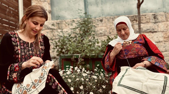
Two women embroidering Tatreez—preserving Palestine’s heritage, stitch by stitch

JERUSALEM
Jerusalem, also called Al-Quds, is a city of profound religious importance for Islam, Christianity, and Judaism alike. Serving as the capital of Palestine, it stands as one of the world’s oldest continuously inhabited cities, with its history stretching back more than 5,000 years. Archaeological findings indicate that the earliest settlements in Jerusalem date to the 4th millennium BCE. Throughout its long history, Jerusalem has been known by various names, such as Urusalim, Aelia Capitolina, Beit Al-Maqdis, and simply “The City.” Its rich past bears witness to a succession of civilizations that have left their mark—from the Bronze and Iron Ages to the Hellenistic, Roman, Byzantine, Crusader, Umayyad, Abbasid, Fatimid, Ayyubid, Mamluk, and Ottoman eras.
For Christians, Jerusalem is a sacred site, home to numerous places tied to the life and teachings of Jesus Christ. Key landmarks include the Church of the Holy Sepulcher, which holds Jesus’s tomb; the Via Dolorosa, the path believed to be walked by Jesus on his way to crucifixion; the Mount of Olives, where Jesus is said to have ascended to Heaven; the Garden of Gethsemane, where he prayed before his arrest; and the Kidron Valley, which contains the Tomb of the Virgin Mary. In Islamic tradition, Jerusalem holds great spiritual value as the first Qibla—the initial direction Muslims faced during prayer—and as the location of Islam’s third holiest sanctuary, following Mecca and Medina. The city hosts the magnificent Dome of the Rock and Al-Aqsa Mosque, both architectural masterpieces dating back to the 7th century CE. The Old City of Jerusalem is divided into four quarters that reflect its diverse cultural and religious heritage: the Muslim Quarter, Christian Quarter, Armenian Quarter, and Jewish Quarter. Its medieval Islamic architecture remains remarkably intact. Encircling the Old City is a wall constructed in the 16th century under the Ottoman Sultan Suleiman the Magnificent. Recognizing its immense cultural and historical value, the Hashemite Kingdom of Jordan added the Old City of Jerusalem to the World Heritage in Danger list in 1981, highlighting both its universal significance and the challenges it faces.


Damascus Gate
Damascus Gate, also referred to as Nablus Gate, stands along the northern wall of the Old City, positioned at the top of the Central Valley’s slope that runs through the city from north to south. Commonly called the Valley, this gate serves as one of Jerusalem’s main entrances and is widely regarded as the city’s principal and most significant access point, celebrated for its stunning architecture and intricate decorations.
The gate’s origins trace back to the Roman era under Emperor Hadrian, who rebuilt the city around 135 AD. Inside the gate’s courtyard, Hadrian erected a tall black granite column, about fourteen meters high, which was topped by his statue. This column was even depicted on the sixth-century Madaba Map. The present structure of the gate, however, dates from the Ottoman era and underwent its latest renovation under Sultan Suleiman the Magnificent in 1538 AD.
The Mount of Olives
Rising to an elevation of 730 meters above sea level, the Mount of Olives overlooks Jerusalem from the east and is the tallest among the hills surrounding the Holy City. The mountain is composed of three main summits: the Ascension Peak, the northern peak which hosts Al-Quds University, and the central peak where Al-Mutala’ Hospital is located.
For Christians, the Mount of Olives holds deep religious importance, as it is linked to many key moments in the life of Jesus. According to tradition, it was from this mountain that Jesus looked out over Jerusalem, mourned its future, and predicted its eventual downfall. Since the 4th century AD, the Mount of Olives has attracted monks, pilgrims, and travelers visiting the Holy Land.
The Church of the Resurrection
The Church of the Resurrection, commonly known as the Church of the Holy Sepulcher, is one of Christianity’s most revered and important sacred sites. Located within the Old City of Jerusalem, it is traditionally believed to be the place where Jesus Christ was crucified (at Golgotha or the Rock of Calvary), died, was buried, and rose again. The original church was constructed in 335 AD by Queen Helena, mother of Emperor Constantine, following her pilgrimage to the Holy Land. During her journey, she identified and ordered the removal of a pagan temple that had been built over the tomb by Emperor Hadrian in the second century AD. Helena’s discoveries included the Holy Sepulcher itself, the Rock of Calvary, and the cross thought to have been used in Christ’s crucifixion. After receiving this information, Constantine commissioned Macarius, the Bishop of Jerusalem, to erect three separate churches: one over the tomb, another over the “Grotto of the Cross,” and a third atop Golgotha.
The church was destroyed by the Persians in 614 AD but was restored by Modestus, the abbot of the Monastery of Saint Theodosius, in 629 AD. In 637 AD, after the Persian occupation, Emperor Heraclius recovered the True Cross. When Caliph Omar entered Jerusalem, he was handed the keys to the city by Patriarch Sophronius. Showing respect for the sacred site, Omar prayed outside the church at the location now known as the Omar Mosque, and he guaranteed Christians religious freedom through the Omari Covenant.
In 1009 AD, the Fatimid Caliph Al-Hakim Bi Amr Allah ordered the destruction of the church, but it was rebuilt in 1048 AD by King Constantine. The Crusaders later expanded and reconstructed the complex, uniting Golgotha, the Holy Sepulcher, and the site of the True Cross into one magnificent structure. When Saladin recaptured Jerusalem in 1187 AD, he honored the church’s sanctity.
The building endured further damage during invasions, including the Tatar-Mongol sack in 1244 AD, but was repaired again afterward.
A notable restoration took place in 1869 when Russia, France, and the Ottoman Empire jointly funded the renovation of the church’s dome above the tomb, continuing its centuries-long legacy of reverence and care.

Al-Samou' Town
Nestled in a mountainous region of the southern West Bank, Al-Samou' lies at an elevation of approximately 700 meters above sea level. Its terrain, characterized by fertile slopes and rugged landscapes, supports the cultivation of grains, olives, figs, and grapes—staple crops of the region. Livestock farming also plays an important role in the local economy, sustained by natural pastures and traditional methods of herding.
The name Al-Samou’ is believed to have Roman origins, possibly derived from the ancient ruler of the region, King Ishtmu. Alternatively, in Arabic, the term is interpreted to signify “hearing and obedience,” adding a layer of cultural meaning to its etymology. Archaeological remains found in the area further underscore its historical depth, with artifacts dating back to the Roman period.
Among Al-Samou’s most prominent historical landmarks is the Samou' Tower, originally constructed as a church in the fourth century AD. This ancient edifice remained a site of Christian worship through the seventh and eighth centuries, after which it was transformed into a mosque during the Ayyubid period, reflecting the broader shifts in the region’s religious landscape.
The tower is a rectangular structure measuring approximately 20 by 10 meters. It features three eastern entrances and a portico supported by two central columns and four corner supports, which once framed the entrance façade. In later periods, the upper sections of the building were reconstructed using original stones, preserving its historical integrity.
Today, the site falls under the supervision of the Palestinian Ministry of Tourism and Antiquities and is safeguarded by a dedicated site guard. The tower attracts a wide range of visitors, including local tourists, scholars, and university students, serving as both a cultural heritage site and a tangible link to the region’s layered past.
Church of the Nativity
The Church of the Nativity, located in Bethlehem, holds the distinction of being the oldest continuously operating church in the world. Its origins date back to the 4th century CE, when Empress Helena—mother of the Roman Emperor Constantine—visited the Holy Land in 325 CE and identified the grotto believed to mark the birthplace of Jesus Christ as the site for a new Christian sanctuary.
Consecrated in 339 CE, the original basilica was constructed in the Roman imperial style, featuring a central nave flanked by four side aisles. A striking mosaic floor, partially rediscovered in 1934, survives as a rare example of early Christian artistry. The structure was designed not only as a place of worship but also as a powerful statement of imperial support for Christianity. The first church suffered severe damage during the Samaritan revolts in the 6th century. It was later rebuilt and enlarged under the orders of Byzantine Emperor Justinian I in 529 CE. This new version included an expanded layout with a grand apse, a narthex (entrance hall), and imposing transepts. Justinian’s reconstruction laid the foundation for the current structure and solidified the church’s importance in the Christian world.
Over the centuries, the Church of the Nativity underwent numerous modifications. During the Crusader period in the 12th century, extensive renovations were carried out, including the installation of a new roof, richly colored mosaics illustrating biblical themes and Christ’s genealogy, and ornate marble floors. The church also became a coronation site for Crusader monarchs and a focal point of religious and political contention between various Christian denominations.
Despite natural deterioration and periodic conflict, the Church of the Nativity has remained a symbol of Christian faith and a revered pilgrimage destination. In recent decades, significant restoration efforts have been led by a Palestinian presidential committee, addressing structural issues such as the collapsed roof and deteriorating mosaics. These efforts have aimed to preserve both the spiritual and architectural integrity of the site.
In recognition of its exceptional universal value, the Church of the Nativity was inscribed on the UNESCO World Heritage List in 2012, also earning a place on the List of World Heritage in Danger due to its condition at the time. Today, it stands not only as a major religious landmark but also as a testament to centuries of devotion, resilience, and cultural heritage rooted in the heart of Bethlehem.
Mar Saba Monastery
Nestled in the dramatic cliffs of the Kidron Valley east of Bethlehem, Mar Saba Monastery stands as one of the oldest and most revered monastic institutions in the Christian world. Founded between 478 and 484 AD by Saint Saba and a community of 5,000 monks, this Eastern Orthodox monastery remains a living symbol of early desert monasticism and spiritual devotion.
During the 4th to 6th centuries, the Judean desert became a cradle of monastic life, with more than a hundred monasteries arising across the arid landscape. These communities followed varying traditions—some monks lived communally, while others adopted a semi-eremitic lifestyle, gathering only weekly to celebrate the Eucharist before returning to their isolated caves.
Mar Saba is renowned not only for its antiquity but also for its resilience. It suffered significant damage during the Persian invasion of 614 AD but was restored just 15 years later. Throughout the centuries, the monastery endured natural disasters, including a major earthquake in the 19th century, and human threats such as Bedouin raids during the Ottoman era. Yet, it has been continuously inhabited for over 1,500 years—a rare feat for any religious site.
The monastery’s architecture reflects both its ascetic ideals and the need for defense. Its sandstone walls rise steeply from the cliffside, with blue-domed chapels, tight passageways, and a central watchtower. Women are not permitted to enter the monastery itself, although they can visit a nearby women’s convent. Inside, life remains rooted in simplicity: monks use oil lamps instead of electric lights and draw water from local springs, continuing centuries-old practices of solitude and prayer.
Saint Saba, who died in 532 AD at the age of 93, was initially buried in the monastery's courtyard. His relics were taken to Venice by the Crusaders but were finally returned to Mar Saba in 1965, where they are now enshrined in a glass sarcophagus within the monastery. Mar Saba Monastery offers a rare glimpse into an unbroken tradition of Christian monasticism, echoing the silence, austerity, and spiritual intensity that have defined this sacred place for over a millennium.

Wadi Qana
Wadi Qana is located 4 km northwest of Deir Istiya and sits 240 meters above sea level. The valley branches off from the main road connecting Deir Istiya to Nablus, heading west. It stretches for 6 km from east to west and connects with Wadi Al-Hamam on the western side and Wadi Al-Mughibeh on the eastern side. Along both sides of the valley lie a number of ancient ruins and springs, the most notable being Khirbet Qana and Khirbet Kafr Qara.
Wadi Qana is a nature reserve that features a network of caves. The most prominent cave, which dates back to the Yarmukian culture, is located south of the village of Kafr Laqif. This natural cave contains stalactites and stalagmites. It was surveyed in 1982 and excavated in 1986. The cave is accessed through a small opening that leads into a narrow passageway, eventually opening into large, irregular chambers.
Excavations revealed three main phases of use. Numerous artifacts and remains from the Yarmukian culture—dating to the late sixth and early fifth millennia BCE—were uncovered, along with items from the Chalcolithic period and the Early Bronze Age I. Traces from the Hellenistic period were also found, though only near the cave entrance. These finds include decorated pottery vessels such as bowls, jars, and cooking pots, as well as spindles, flint tools, grinding stones, and various agricultural implements used by the cave’s inhabitants.
The second Chalcolithic phase marks the cave’s primary use as a burial site. One of the most significant discoveries consists of burial goods, including pottery, basalt and ivory vessels, beads, and copper tools. Notably, eight gold and electrum rings were found near a child’s burial. The cave's most exceptional finds are a collection of objects made of copper, electrum, and nearly pure gold—eight items made entirely of gold, others of electrum. These artifacts represent the earliest known gold and electrum production in Palestine to date.
Beit Lid
Perched on a lush hillside, Beit Lid offers a striking fusion of rich history and contemporary life. At its heart lies the “tourist village,” a standout attraction built over a former Roman-era stone quarry in the Old Town. Today, this area has been transformed into a multi-functional site—part archaeological marvel, part leisure destination, and a popular venue for weddings and community events.
Beyond this central site, the Old Town of Beit Lid enchants visitors with its winding alleys, lined with local shops offering fresh produce, street food, and daily essentials. Located southwest of Tulkarem, Beit Lid is also a vital agricultural center, known for its abundant orchards. Farmers here cultivate olives, almonds, figs, and grapes in the fertile valleys surrounding the town.
GAZA
Situated along the Mediterranean coast, about 32 kilometers north of Egypt’s border, Gaza City is regarded as one of the world’s oldest continuously inhabited urban centers. Its strategic location on the ancient coastal trade route made it a thriving commercial hub, historically serving as a key stop between Egypt and Syria.
In antiquity, Gaza was a prominent Philistine city during the early Iron Age and was associated with the worship of the Canaanite fertility deity Dagon. It is referenced multiple times in the Bible—most notably as the site where Samson, according to tradition, brought down the Philistine temple. In 734 BCE, the Assyrian ruler Tiglath-Pileser III conquered Gaza, and it remained under Assyrian control until the mid-7th century BCE. Under the Babylonians in the 6th century BCE, Gaza became a significant fortress city.
Gaza experienced considerable development during the Hellenistic and Roman periods. The ancient historian Herodotus referred to it as Kadytis. In 332 BCE, Alexander the Great captured the city after a protracted siege. During Roman rule, Gaza evolved into a vibrant urban center, with temples honoring Zeus, Aphrodite, Apollo, and the local deity Marnas. The city expanded beyond its original core, and the port of Maiumas was established to facilitate maritime trade.
During the Byzantine era, the city was renamed Constantia, and in the 5th century CE, a large church was built on the ruins of the Temple of Marnas. Gaza was depicted on several ancient maps and mosaics, including the 6th-century Madaba Map and the 8th-century mosaic floor in the Church of Saint Stephen at Umm ar-Rasas, both of which highlight its prominence.
In 636 CE, Gaza fell under Islamic rule. It gained spiritual significance as the burial place of Hashim, the grandfather of Prophet Muhammad, and as the birthplace of Imam Al-Shafi‘i. A Christian presence also persisted, with the Church of John the Baptist built on the site of the earlier Eudoxiana. The city was seized by Saladin in 1187 and integrated into the Ayyubid realm.
Under Mamluk rule, Gaza rose to become a provincial capital. The Ottomans took control in 1516, maintaining Gaza's status as a vital trading post on the routes linking Egypt, the Levant, and Arabia. The city prospered under Ottoman administration. From 1918 to 1948, Gaza was governed by the British Mandate, followed by Egyptian control until the 1967 war, after which it came under Israeli occupation. In 1995, as part of the Oslo Accords, authority was partially transferred to the Palestinian National Authority, granting Gaza a degree of self-rule.
To this day, Gaza remains under a land, air, and sea blockade imposed by Israel, which, combined with recurrent military operations, continues to isolate the territory and hinder its recovery. The ongoing restrictions and periodic escalations have left Gaza’s ancient heritage, economy, and population in a state of profound vulnerability, turning one of the world’s oldest cities into a symbol of both historical richness and enduring human suffering.

The Great Mosque
The mosque is located in the center of Gaza City at the end of Omar Al-Mukhtar Street, and was named in honor of the second of Caliph Omar Ibn Al-Khattab. It is said that the mosque was built over an ancient temple of Marnas, then converted into a Byzantine church and then into a mosque at the beginning of the Islamic conquests.
The current plan of the mosque preserved parts of the church built by the Frankish Normans in the twelfth century AD, which was built in the Gothic style. The mosque was rebuilt and expanded during the Mamluk and Ottoman periods, and the minaret was built during the Mamluk period and is one of the most prominent components of the mosque.

RAMALLAH AND AL-BIREH
The name Ramallah is derived from two components: Ram, an Aramaic term meaning high place, and Allah, denoting majesty. This name was adopted during the Islamic era, while during the Crusader period, the city was known as Ramilia. Located 16 kilometers north of Jerusalem at an elevation of 900 meters, Ramallah is often called the Bride of Palestine due to its stunning natural landscapes. Situated next to the city of Al-Bireh, Ramallah stands out as one of the wealthiest, most culturally vibrant, and progressive cities in Palestine.
Today, Ramallah offers a blend of modern life and cultural heritage, featuring a bustling town center, renowned museums, art galleries, theaters, and a diverse selection of upscale restaurants and hotels. The city’s leafy public parks and warm, welcoming residents add to its charm, making Ramallah a must-visit destination for those eager to experience the dynamic heart of Palestinian society. Whether drawn by its natural beauty, cultural vibrancy, or cosmopolitan lifestyle, visitors to Ramallah are sure to be enchanted by this multifaceted jewel at Palestine’s core.
The name Al-Bireh originates from an Aramaic word Berta, meaning castle or fortress, reflecting the area's ancient roots where Aramaic was spoken. Situated 16 kilometers north of Jerusalem, on the central ridge between Jerusalem and Nablus, Al-Bireh rests on a cliff about 800 meters above sea level. The city is rich in archaeological remains from various historical periods, including Byzantine, Crusader, Mamluk, and Ottoman eras. The old town hosts numerous historical monuments such as a khan, a church , religious shrines, and ancient buildings, blending historical architecture with modern structures. Al-Bireh is also known for its many natural springs and water sources, some of which historically supplied drinking water (like Ain Al-Jame’ or the Mosque Spring), irrigation, and powered water mills, such as those near Al-Jinan springs south of the city. Although most springs have dried over time, a few remain active, including Ain El-Jame’, Ain Sidi Shayban, Ain Umm Al-Sharait, and Ain Al-Jinan.
Archaeological evidence in Al-Bireh dates back to the Bronze Age, with remnants of ancient settlements still visible. Near Al-Bireh-Nablus Street, Crusader-era church ruins can be found at the heart of the old city, while Tal Al-Nasbah, located west of Jerusalem Street, was excavated during the early 20th century. In the 17th century, Al-Bireh saw an influx of immigrants from Al-Karak in Jordan, led by Hussein Tanash and his group, shaping the town’s demographic development. This migration halted after the 1967 occupation, yet the city maintains close ties with large Palestinian-American expatriate communities. Following the 1948 Palestinian exodus, Al-Bireh became home to many displaced Palestinians from cities like Lod, Ramleh, and Jaffa, further enriching its cultural fabric. Today, Al-Bireh is valued as a summer resort destination, admired for its favorable weather and historical significance.
Khan Al-Bireh
Originally called the Curia during the Crusader era, this building functioned as the central court for legal proceedings. During the Ottoman period, it became known as Khan Al-Bireh. The site is located east of Almughtaribeen Street and just south of Khawla Bint Al-Azwar School, resting on the southern slope of the Crusader settlement of Bireh.
Dating back to the Crusader period, the building was part of the southern complex of the Crusader settlement and served as a key administrative center for the Hospitallers. It was then called the Curia, acting as the hub for legal and administrative matters. Historical records from 1151 AD indicate that Judge Arnulfs Jouri was assigned to oversee the court here, alongside a representative from the Church of the Holy Sepulcher. Later, under Islamic rule, the building’s role shifted to serve as a caravanserai or rest stop for travelers, merchants, and pilgrims journeying between Jerusalem and Nablus, which led to its name Khan Al-Bireh.
The structure was originally built in the Romanesque architectural style with a rectangular footprint of roughly 60 by 45 meters. However, natural decay has reduced its remains to about 16 by 14 meters. Architecturally, it features pointed arches supported by intersecting arches crafted from finely dressed stones. In 1997, the Ministry of Tourism and Antiquities’ Antiquities Department undertook restoration efforts that included cleaning and excavations. Damaged walls and ceilings were repaired, and the building was transformed into a museum, now known as the Khan Al-Bireh Museum.
Today, the museum acts as a cultural heritage center, dedicated to preserving and showcasing the city’s historical treasures. It houses a permanent exhibition displaying important archaeological artifacts from Al-Bireh, categorized by their excavation sites, along with a multipurpose hall and facilities for workshops and laboratories.

Mahmoud Darwish Museum
Perched on a hill with views toward Jerusalem, the Mahmoud Darwish Museum spans approximately 9,000 square meters in Ramallah’s Masyoun neighborhood, directly opposite the Ramallah Cultural Center. The museum complex features a public garden housing the tomb of Mahmoud Darwish, a memorial museum, a multi-purpose hall, an outdoor theater, recreational parks, and water features. Visitors can explore a collection of personal memorabilia, including original manuscripts and private belongings of the late poet. The museum also offers a video exhibition hall and a specialized library that holds Darwish’s writings, poetry collections, and various literature-related works.

JERICHO
Located 36 kilometers east of Jerusalem, Jericho occupies a unique place at the crossroads of history and geography. Situated along the route to Amman and at the junction of the highway leading to the Galilee, Jericho is home to the ancient site of Tel as-Sultan. Widely regarded as the oldest continuously inhabited town in the world, Jericho’s origins date back over 10,000 years. Positioned approximately 250 meters below sea level, it is both the lowest and the oldest known town globally. The mound covering the town’s ruins spans about one acre.
Jericho has been referenced in numerous historical sources, with archaeological finds including seals inscribed with its name from the Middle Bronze Age (second millennium BC) during the Canaanite period. Extensive excavations reveal a rich cultural history stretching over 10,000 years. The earliest traces belong to the Natufian culture (10th–8th millennium BC), including flint tools and evidence of a hunting camp near the spring. The early Neolithic settlement features round mud-brick houses enclosed by a wall and a circular tower—the oldest known fortification system.
As the world’s oldest city, Jericho played a key role in early Christianity. During the late Hellenistic to early Roman era, significant housing was concentrated at Tulul Abu Al-Ala'iq, also known as Herod’s Palace, a vast complex. By the late Roman and Byzantine periods, the city’s administrative center shifted to what is now modern Jericho. The city appears on the sixth-century Madaba mosaic map, depicted with a church and a palm tree labeled “St. Elisha,” alongside landmarks such as the Jordan River and the Dead Sea.
Recent archaeological work in Jericho’s historic core has unearthed important Byzantine remains, including several churches: Tell al-Hassan, the Coptic Orthodox Church, the Greek Orthodox Church of Abuna Anthimos, and Khirbat an-Nitla. A colorful mosaic floor was uncovered in 1962. Around 2010, during the construction of the Russian museum in Jericho, a Palestinian-Russian team conducted salvage excavations revealing additional buildings from the early Roman, Byzantine-Umayyad, Medieval, and Ottoman periods.
Over the past decade, the Palestinian Department of Antiquities, in partnership with Sapienza University of Rome and UNESCO, has undertaken rehabilitation projects at Tell al-Sultan. These efforts continue to highlight Jericho’s significance as a cradle of some of humanity’s earliest civilizations. Today, Jericho’s moderate climate and low elevation make it a popular winter retreat, with temperatures warmer than most of Palestine. Its fertile soil supports a thriving agricultural industry renowned for fresh produce such as dates, bananas, and citrus fruits. From its ancient archaeological treasures to its modern agricultural wealth, Jericho stands as a symbol of the enduring resilience and adaptability of human settlement in the Levant.

The Shrine of Nabi Musa
Nestled within a stark desert environment, the Shrine of Nabi Musa stands as a prime example of Mamluk Islamic architecture in its simplest form. This sacred site contains the tomb of the Prophet Moses, a highly respected figure in Islamic tradition. The shrine was established by Sultan al-Zahir Baybars and is located about 8 kilometers south of Jericho and roughly 28 kilometers east of Jerusalem.
Situated in a remote and sparsely vegetated area, the shrine rests atop hills composed of sulfur and sedimentary rock. Covering an area of approximately five dunums, the complex consists of a mosque and a mausoleum centered around the tomb itself. It comprises three upper floors and a ground level, along with nearly one hundred rooms—some open to visitors, others sealed off. At its heart lies a spacious courtyard designed to welcome large numbers of pilgrims.

Baptismal Site
This location holds deep religious significance for Christians as the place where Jesus was baptized by John the Baptist, marking the beginning of his ministry and the gathering of his first followers, including Andrew, Peter, and Philip. The ancient walls found here date back to the first century AD and bear crosses carved by early pilgrims journeying from Jerusalem to Mount Nebo. Over time, this spot became a recognized baptismal area situated below marble steps leading to a spring near the Church of St. John the Baptist. Both monks and saints have confirmed its sacred importance, making it a favored gathering place for Christian pilgrims and visitors along the Jordan River today.
The site itself is divided into two main parts: the first, known as Tel al-Kharrar or Jabal Mar-Elias (Elijah’s Hill), where remains of an ancient monastery have been discovered; the second area, called Zour, lies about 2 kilometers east near the river. Zour hosts the ruins of the ancient Church of St. John the Baptist, baptismal pools, additional church remains, and accommodations once used by pilgrims. The site includes various churches dating back to the Byzantine era, as well as caves nearby that served as hermitages for monks.
Archaeological finds from both Byzantine and Roman periods highlight the site’s long history as a major pilgrimage destination. Between 491 and 518 AD, the Byzantine Emperor Anastasius commissioned the first Church of St. John the Baptist, which was later destroyed by Persian forces in 614 AD. In the 13th century, a Greek Orthodox monastery was established. After the occupation of the West Bank, Christians were barred from visiting until 1985, when access was restored.

Al-Khadra Mosque (Hizn Sidna Yaq'ub Mosque)
Located in the Old City of Nablus, the Al-Khadra Mosque—also known as Hizn Sidna Yaq'ub—covers roughly 1,345 square meters. It can be accessed from a western gate connected to Ras Al-Ein Street, as well as from another gate that opens onto nearby historic neighborhoods.
The mosque features a northern open-air courtyard that has been modernized with new stairways, a water fountain, and other facilities. Among the most striking architectural elements is the north-facing central gate, which is framed by beautifully interwoven stone arches. A marble inscription above this gate attributes the mosque’s construction or renovation to the year 1279 AD, during the rule of the Mamluk Sultan al-Malik al-Mansur Qalawun
Inside, the mosque consists of a rectangular prayer hall, supported by intersecting stone arches that form an eye-catching vaulted ceiling. On its western side, a door opens into a natural rock-cut cave, adding to the site’s historic and spiritual atmosphere. A particularly notable feature of Al-Khadra Mosque is its minaret, which is separated from the main building by a residential structure. This minaret stands out for its square design—a rare architectural element in Palestine—and reflects classic Mamluk style.
In 2002, during the Israeli incursion into Nablus, the mosque’s northwestern section suffered significant damage. However, the Nablus Municipality undertook its restoration following the end of the invasion, preserving the site’s religious and historical legacy.
Al-Badr Soap Factory
Al-Badr is one of the few remaining traditional soap factories still operating in Nablus today—just five are active, a small fraction compared to their historical number. Though modest in production, the factory continues a family legacy that spans generations. The current director inherited the business from his father, Muath al-Nabulsi, a former head of the Nablus Chamber of Commerce, before handing the reins to the next generation.
Architecturally, the factory follows the typical Ottoman industrial style. It is built from local limestone, with robust stone foundations and vaulted ceilings supported by intersecting arches. The structure includes two main floors, and some sections feature a third level, which historically served as residential space for the factory owner.
The ground floor serves as the operational heart of the production process. It houses the manager’s office, as well as massive copper vats—each weighing around a ton—used to boil the soap mixture. Nearby are underground storage wells with a total capacity of about 50 tons, used to hold the olive oil essential to the soap's formula. These vats are enclosed by fire-resistant bricks and stone, and are located next to a small water cistern and an oven used to maintain heat during the week-long cooking process. This level also stores caustic soda and dried olive pits, both crucial for soap production and fuel. The second floor, known locally as Al-Mufrad, is where the final stages take place. Here, the soap is poured out, cooled, cut, marked with the factory’s seal, dried, and then packaged for sale or export. Remarkably, the original tools and production materials are still in use, carefully maintained to preserve the authenticity of the process.
Historically, each soap factory in Nablus employed around 15 workers, making the industry an important part of the city’s economy. At its peak, Nablus boasted nearly 40 soap factories. Over the decades, however, the sector has declined due to a combination of factors: the 1927 earthquake, rising olive oil prices, competition from modern scented and liquid soaps, and the damage caused by the 2002 Israeli military incursion. These events forced many factories to shut down, leaving only a small number of family-run workshops to keep the tradition alive.

Al-Ibrahimi Mosque
Positioned in the southeastern part of modern-day Hebron, the Ibrahimi Mosque—also known as Al-Haram Al-Ibrahimi—stands as one of Islam’s most revered places of worship. Though now on the city’s edge, in antiquity the mosque lay at Hebron’s center, encircled by densely populated quarters. It is considered the fourth holiest site in Islam and holds immense significance in Palestine, second only to Al-Aqsa Mosque.
The sanctity of this site stems from its role as the burial place of the patriarch Abraham (Ibrahim), his wife Sarah, their son Isaac, grandson Jacob, and the matriarchs Rebecca and Leah. This deeply rooted religious importance is reflected in centuries of reverence across faiths and empires.
The mosque is built within a colossal stone enclosure dating back to the reign of King Herod (37–4 BCE) during the Roman period. The Herodian walls, formed from massive hewn limestone blocks—some measuring over 7.5 meters in length—rise to more than 15 meters high. These ancient walls have endured for over two millennia, marking the site as a monumental architectural feat.
During the Byzantine era, a Christian church was erected inside the Herodian enclosure, only to be destroyed during the Persian conquest of 614 CE. When Muslim forces took control of Palestine in 638 CE, the site was transformed into a mosque. Domed shrines were placed over the patriarchal tombs, and the site became a key pilgrimage destination for Muslims across the Islamic world. The Crusader occupation in 1100 CE brought another transformation: the mosque was turned into a church and fortress known as the "Castle of Saint Abraham." Following Saladin’s victory in 1187 CE, the mosque was restored to Islamic worship. Saladin also commissioned the construction of four minarets, two of which still stand today.
During the British Mandate era, the Supreme Islamic Council implemented important architectural restorations. Under Jordanian administration (1948–1967), further enhancements were made, maintaining the mosque's historical and religious character. However, the occupation of Hebron by Israel in 1967 marked a period of intensified tension around the site. The Ibrahimi Mosque has been repeatedly targeted by settler violence, culminating in the 1994 massacre when a Jewish extremist opened fire on Muslim worshippers during prayer, killing 29 people and injuring many more. In response, Israeli authorities imposed a controversial division of the mosque, allocating the majority—around 60%—for exclusive Jewish use, with the remainder left for Muslims. This partition, along with heavy military presence and restrictive checkpoints, continues to undermine Muslim access and freedom of worship.
Despite these challenges, the Ibrahimi Mosque remains a powerful symbol of spiritual devotion and resilience, its walls bearing silent witness to centuries of faith, conquest, and survival.

The Old City of Hebron
Situated in the southeastern quadrant of modern Hebron, the Old City evolved around the sacred precinct of the Ibrahimi Mosque. Its current urban configuration dates back to the early Islamic period, when the city’s center shifted from the ancient hill of Tel Rumeida to the area encircling the mosque. Hebron gained prominence as a religious and cultural hub during the Mamluk period (1250–1517), with the Old City developing into a complex urban space composed of neighborhoods, religious institutions, marketplaces, and public infrastructure.
By the end of this era, the Old City encompassed thirteen identifiable neighborhoods, each characterized by its own social fabric and spatial organization. The Ottoman period (1516–1917) brought further expansion, consolidating the physical and architectural form that largely defines the Old City today.
Reflecting traditional Islamic urban planning, Hebron’s historic quarters were designed with privacy, security, and community in mind. Neighborhoods such as Sheikh Ali al-Bakka, Qaytun, and Bab al-Zawiya formed concentric layers around or near the mosque, each with fortified entrances and gates that were locked overnight until the early 20th century. The city’s design transitioned methodically from public to private realms: from main roads (public), to communal squares (semi-public), winding alleys (semi-private), shared courtyards (semi-private), and finally, to individual homes (private). This structure not only fostered social cohesion but also enhanced the safety of its residents.
In 2017, UNESCO inscribed the Old City of Hebron on both the World Heritage List and the List of World Heritage in Danger, under criteria (ii), (iv), and (vi). The inscription recognizes Hebron as a remarkable example of a city where intercultural exchange and religious traditions have profoundly shaped architecture, construction methods, urban development, and cultural expression. The legacy of Prophet Ibrahim (Abraham)—revered for his hospitality and generosity—remains embedded in the city’s social customs, most notably in the continued operation of the Ibrahimi Takiyya, a historic public kitchen offering free meals to travelers and the needy.
The Old City’s heritage continues to reflect centuries of spiritual devotion, architectural ingenuity, and the resilience of a population committed to preserving its identity amid profound political and social transformations.
BETHLEHEM
Internationally recognized as the birthplace of Jesus Christ, Bethlehem holds immense religious, historical, and cultural significance. Located just a few kilometers south of Jerusalem, the city is a focal point for Christian pilgrims and travelers drawn by its sacred landmarks and enduring spiritual legacy.
Archaeological evidence indicates human settlement in the Bethlehem area as far back as the Chalcolithic, Bronze, and Iron Ages. Early communities were likely centered on the fertile lands of nearby Beit Sahour and gradually moved uphill to the ridge where the Church of the Nativity now stands. During the Hellenistic and Roman periods, the city's prominence increased, particularly after the construction of an aqueduct that supplied water from Solomon’s Pools to Bethlehem and Jerusalem.
Bethlehem’s central importance lies in its association with the nativity of Jesus. According to Christian tradition, Jesus was born here during the reign of King Herod. In the fourth century AD, the Roman Emperor Constantine the Great and his mother Helena commissioned the construction of the Church of the Nativity, built over the grotto believed to mark the exact birthplace of Christ. This basilica, which has been preserved and expanded over the centuries, is considered one of the oldest continuously operating churches in the world and remains the spiritual heart of Bethlehem.
Several other revered Christian sites surround the Church of the Nativity. These include the Milk Grotto, where tradition holds that Mary nursed the infant Jesus, and the Shepherds' Fields, where angels are said to have proclaimed his birth to local shepherds. These sacred spaces offer pilgrims a tangible connection to the Gospel narrative and the early life of the Holy Family.
Bethlehem is also home to a vibrant Palestinian community and a rich cultural heritage. The Old City, with its narrow alleyways and historic stone architecture, invites visitors to explore its bustling markets, traditional artisan workshops, and family-run shops selling olive wood carvings, hand-embroidered garments, and local delicacies. The city’s atmosphere is further enriched by its warm hospitality and dynamic cultural life.
Whether one visits for spiritual reflection or historical interest, Bethlehem offers a profound experience. It is a place where ancient history, living faith, and cultural resilience converge—inviting every visitor to engage with a narrative that continues to shape the beliefs and imaginations of millions around the globe.

Herodion
Perched atop an artificial hill 6 kilometers southeast of Bethlehem, Herodion is a striking archaeological site that seamlessly blends natural landscape with monumental architecture. Though it may resemble a natural hill from afar, this circular fortress-palace was meticulously constructed by King Herod the Great between 23 and 18 BCE as both a royal residence and a symbol of his authority.
Herodion was one of Herod's most ambitious architectural endeavors, showcasing the king’s penchant for grandeur. The summit featured an opulent circular palace encased within fortified walls. This elegant complex included luxurious living quarters, Roman-style bathhouses, reception halls, and ornamental gardens arranged over several terraces. Its elevated location provided both strategic defense and breathtaking views, including expansive vistas of the Judean Desert and the Dead Sea.
Functioning as both a military stronghold and a private retreat, Herodion also held great personal significance for Herod, who chose it as the site for his burial. Excavations have revealed impressive remnants of the palace’s massive towers, colonnades, staircases, and sophisticated water systems—an enduring testament to the architectural innovation of the period.
Today, Herodion stands as a prominent archaeological and historical landmark. Its dramatic silhouette continues to dominate the landscape southeast of Bethlehem, inviting visitors to explore the legacy of one of antiquity’s most controversial and influential rulers. From the summit, the panoramic views and the scale of Herod’s vision offer a powerful window into the political ambition and cultural richness of ancient Palestine.

SALFIT
Salfit is surrounded by fertile hills and valleys that support a thriving agricultural sector, particularly the cultivation of olives, figs, grapes, almonds, and apples. The area's rich soil and favorable elevation have long sustained farming traditions.
A key natural highlight is the Wadi Qana Reserve, a biodiverse valley shared with the Qalqilya Governorate. This protected area is home to unique flora and fauna, offering scenic views and an important ecological refuge amid the region's agricultural landscape.
TULKAREM
Situated just 12 kilometers from the Mediterranean Sea and about 15 kilometers west of Nablus, the flourishing town of Tulkarem enjoys a pivotal location between the coastal plains and the central highlands of Palestine. This geographic setting has historically positioned Tulkarem as a crucial stop along trade and military routes that have crossed the area for centuries.
Tulkarem's roots go back to the Canaanite era, when it was called "Tur Karm," meaning "Mountain of Vineyards," a name that reflects the area's fertile terrain and its long-standing agricultural traditions. During the Ayyubid and Mamluk eras (1260–1516 CE), much of the town’s farmland became part of a waqf—a religious endowment—dedicated to supporting Al-Madrasa al-Farisiyya in Jerusalem.
Over the centuries, the town has prospered thanks to its rich soil, which has produced plentiful crops such as grains, citrus, olives, and other agricultural goods. This robust agricultural sector has played a central role in establishing Tulkarem as an important hub of commerce and culture in Palestine. Combining its advantageous location, historical depth, and strong agricultural heritage, Tulkarem exemplifies the resilience and ingenuity that define Palestinian towns throughout the region.

Al Barqawi Castle, Town of Shufa
Named after the Al Barqawi family and Sheikh Issa Al Barqawi, this historic castle is located in the center of Shufa village, around 8 kilometers southeast of Tulkarm. Dating back to the Ottoman era, the structure boasts more than 25 rooms and showcases architectural features typical of the feudal style in Ottoman-era Palestine.
Considered one of the most prominent castles in the Tulkarem area, it holds significant historical value from the late Ottoman period. It was a key site during various pivotal moments, such as the resistance to Napoleon's 1799 campaign—where Sheikh Khalil Al-Barqawi lost his life—and Ibrahim Pasha’s suppression of the peasant uprising in 1831. The castle also played a notable role during the 1936 Palestinian revolt against British colonial rule.
The building consists of a basement and two upper floors. The basement includes several rooms, wells, and storage areas, with some sections believed to have functioned as holding cells. Today, part of the basement has been repurposed as a museum exhibiting local heritage artifacts. The first floor contains different areas such as an iwan, guest rooms, residential quarters, service areas, a kitchen, and stables. Surrounding the structure are open yards with horse stables, training grounds, servant quarters, livestock barns, and an olive press. The top floor was reserved for the sheikh and his close companions and includes private living spaces and lookout points. Some portions of the castle, especially on the western side, have collapsed, and other sections in the southwest remain in a state of disrepair.

Dar Al Sheikh / Al-Barqawi Castle – Kafr al-Labad
Constructed during the Ottoman era, this castle is one of four fortresses affiliated with the influential Al-Barqawi family in the region. Situated in the heart of Kafr al-Labad, the structure spans approximately 968 square meters, including an open courtyard measuring around 490 square meters. The castle is composed of a series of rooms and distinctive architectural elements, such as water cisterns, elite living quarters (lofts), servant rooms, and various agricultural outbuildings like horse stables and animal barns. The design features traditional archways and a knee-bracing construction technique, while limestone was the primary building material—typical of regional Ottoman architecture.
Founded by Sheikh Issa Al-Barqawi in the Wadi Al-Shaer area, the castle served as a significant seat of influence for the Al-Barqawi sheikhdom throughout both the Ottoman and British Mandate periods. It was a key landmark of their political and social power in the area. In 2011, the site was carefully restored by the Palestinian Ministry of Tourism and Antiquities, in partnership with the Riwaq Centre for Architectural Conservation. Today, it stands as a preserved symbol of the Al-Barqawi family's historical presence and the architectural heritage of the region.
Sayyed Hashem Mosque
Located in Al-Daraj Quarter, the mosque is one of the biggest and most beautiful in Gaza. The tomb of Prophet Muhammad’s grandfather Hashem Bin Abdulmanaf, who died in Gaza during a trading voyage, is believed to be under the dome of the mosque.